|
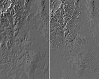
Canberra, Australia (SPX) Dec 16, 2008 CSIRO is building a three-dimensional computer model of Australia's ground surface topography at scales never seen before. "The new one-second Digital Elevation Model (DEM) provides nearly ten times finer resolution and much greater detail than previous models," says CSIRO researcher and project leader, Dr John Gallant. "It dramatically improves our understanding of Australia's landscape and this will transform the management of Australia's water resources." The one-second DEM development is a key activity within the water information research and development partnership between CSIRO's Water for a Healthy Country Flagship and the Bureau of Meteorology's Improving Water Information Program. "It will give the Bureau a reliable definition of stream networks and catchment boundaries needed to calculate water movement through the landscape," Dr Gallant says. Based on the Shuttle Radar Topographic Mission (SRTM) data collected by NASA during a Space Shuttle mission in 2000, the new one-second (about 30m resolution) DEM is a vast improvement on the previous nine-second (about 250m resolution) version. The SRTM data has been available since 2005, but its use was limited by reflections from areas of dense vegetation cover which misrepresented the pathways for water flow in the landscape. "This masked the detail in low-relief landscapes where most of Australia's farming takes place so it was our mission to clean up the data and reveal the hidden picture," Dr Gallant says. It has taken over three years to develop the methods to remove the vegetation and other contaminating signals in the data. The first phase of removing unwanted signals is now complete and the data set will be delivered by CSIRO and collaborators, Geoscience Australia and the Australian National University, to the Defence Imagery and Geospatial Organisation today. This data will be useful for a variety of applications including correcting remote-sensed imagery, calculating coverage of mobile phone towers and rendering three-dimensional visualisations of the Australian landscape. The final phases in building the one-second DEM will occur over the next year with the removal of vegetation effects and inclusion of Australia's river network. The data will be licensed and managed by Geoscience Australia. It will be available to all tiers of Australian government who can release it to their authorised contractors and collaborators. A three-second version (about 90m) of the DEM will be available for public use. Related Links Water for a Healthy Country Flagship Earth Observation News - Suppiliers, Technology and Application
 Hanoi, Vietnam (XNA) Dec 15, 2008
Vietnam plans to launch its first remote sensing satellite by 2012, the local newspaper Vietnam News Agency reported Friday. The country is now carrying out its satellite-launching project, worth about 100 million U.S. dollars. |
|
| The content herein, unless otherwise known to be public domain, are Copyright Space.TV Corporation. AFP and UPI Wire Stories are copyright Agence France-Presse and United Press International. ESA Portal Reports are copyright European Space Agency. All NASA sourced material is public domain. Additional copyrights may apply in whole or part to other bona fide parties. Advertising does not imply endorsement, agreement or approval of any opinions, statements or information provided by Space.TV Corp on any Web page published or hosted by Space.TV Corp. Privacy Statement |