|
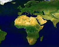
Cape Town (AFP) Nov 28, 2007 China and Brazil will give Africa free satellite imaging of its landmass to help the continent respond to threats like deforestation, desertification and drought, the two countries said Wednesday. A land imaging satellite launched by the two governments at a cost of some 100 million dollars in September, would relay images, updated monthly, to four ground stations for dissemination to African states. "How much is it worth for (Africa) to have an up-to-date mapping of its agricultural areas? It is priceless," Gilberto Camara, director general of Brazil's National Institute for Space Research, told AFP. He was attending a gathering in Cape Town arranged by the Group on Earth Observations (GEO) on new ways to monitor and share information on the Earth's ailing health. China and Brazil announced their plan on the sidelines of the conference, saying they wished to contribute to sustainable development and risk management in Africa. "This (mapping) will empower governments and organisations in Africa to use satellite imagery to monitor and respond to emerging natural disasters, deforestation, desertification and droughts, threats to agricultural production and food security and emerging health risks," a statement said. The data would be made available to environmental and research institutions, as well as public and private bodies responsible for land management. "Does anyone know how much rain forest exist in Africa?" asked Camara. "No. Does anybody know the total area used for crops in the whole of Africa? This is all about forward planning." And what do Brazil and China get in return? "A better world," he said. "If there is one lesson in the history of humanity, it is that generosity pays itself in the long run. "Everybody needs to manage the planet. Everything we do, each one of us, has consequences." China and Brazil would also sponsor the software needed by the four ground stations to read the satellite data. The first ground station, in South Africa, would start receiving satellite data immediately, said Camara. The station in Kenya would follow early next year, and those in the Canary Islands and Matera, Italy, by next June. The GEO gathering, attended by ministers and officials from over 100 governments and international bodies, is reviewing progress with the global integration of national monitoring systems to enhance real-time information on environmental change. It is hoped a resulting GEO System of Systems (GEOSS) would enable countries to reduce their vulnerability to environmental change and disasters and improve their management of agricultural, energy and other resources. Related Links Earth Observation News - Suppiliers, Technology and Application
 Washington DC (SPX) Nov 28, 2007
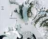
A team of researchers from NASA, the U.S. Geological Survey, the National Science Foundation and the British Antarctic Survey unveiled a newly completed map of Antarctica today that is expected to revolutionize research of the continent's frozen landscape. The Landsat Image Mosaic of Antarctica is a result of NASA's state-of-the-art satellite technologies and an example of the prominent role NASA continues to play as a world leader in the development and flight of Earth-observing satellites. |
|
| The content herein, unless otherwise known to be public domain, are Copyright Space.TV Corporation. AFP and UPI Wire Stories are copyright Agence France-Presse and United Press International. ESA Portal Reports are copyright European Space Agency. All NASA sourced material is public domain. Additional copyrights may apply in whole or part to other bona fide parties. Advertising does not imply endorsement, agreement or approval of any opinions, statements or information provided by Space.TV Corp on any Web page published or hosted by Space.TV Corp. Privacy Statement |