 |
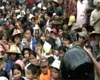
Atlanta GA (SPX) Oct 09, 2008 Researchers at the Georgia Tech Research Institute (GTRI) have developed a low-cost, high-resolution imaging system that can be attached to a helicopter to create a complete and detailed picture of an area devastated by a hurricane or other natural disaster. The resulting visual information can be used to estimate the number of storm refugees and assess the need for health and humanitarian services. Aid organizations currently don't have a quick and accurate way to determine how many people need assistance. Satellites can collect images of areas affected by a natural disaster, but there are dissemination restrictions and cloud cover can prevent collection of images. "Without a real-time map, it's very hard to do population estimates and demographic estimates to figure out where people are, how they're moving, how they're spaced out and even how many people you have on the ground," said Benjamin Sklaver, a project officer from the Centers for Disease Control and Prevention (CDC) International Emergency and Refugee Health Branch. "This technology does not exist currently, so GTRI's imaging system is really an innovative project." The imaging system was developed with funding from the CDC, and agency officials would like to begin using this device as soon as possible. After responding to the recent devastation caused by Hurricanes Hanna and Ike, the CDC asked GTRI to accelerate delivery of the imaging device for use during the 2008 hurricane season. "We plan to package the system for use on Coast Guard UH-60J Black Hawk helicopters, which were among the first to fly over Haiti following Hanna's devastation," said David Price, a GTRI senior research technologist. The imaging system - designed by Price and senior research engineer Gary Gray - is called the "Mini ModPOD," which stands for "Miniature Modular Photographic Observation Device." It consists of an off-the-shelf Canon Digital Rebel XTi digital camera, a global positioning system receiver, a small circuit board that uploads mission parameters, and an inertial measurement unit that measures the aircraft's rate of acceleration and changes in rotational attributes, including pitch, roll and yaw. The images collected from the system can be stitched together to create a complete picture of the affected area. The research team has tested the device on several flights, selecting areas with large populations of people likely to be outdoors. "During the first test flight, we wanted to test the clarity and resolution of the images collected during the run, and we were very pleased," said Price. "We could see tennis balls on the ground and people reading books at outdoor tables. This was sufficient detail to allow accurate counting the number of people in an area." After the first flight, the researchers reduced the weight of the device and developed a more accurate geo-referencing capability, which allowed the physical location of the scenes shown in each photograph to be determined with precision. With the modifications made, the researchers went for a second flight test in July. The research group selected a rectangular zone of interest and loaded the latitude and longitude coordinates of the zone into the system from a USB drive. As soon as the helicopter flew into the zone, the camera began snapping pictures. The electronics were set to measure the speed of the aircraft so that each photo overlapped 60 percent of the preceding photo, making it easier to stitch together the photos to create a complete picture. The pilot made two passes, at altitudes of 500 and 1,000 feet above ground level. "This test flight was successful in confirming the Mini ModPOD's ability to activate the camera within the zone of interest. The resulting photos were extremely sharp and clear - they were free of any vibration or motion effects," added Price. The photos were successfully matched to the flight data, which enabled the CDC to adjust them for geospatial reference. However, due to a software glitch, they were not overlapped as planned. The researchers made a small adjustment to the software and completed a third a third test flight in August. "This flight resulted in images that were 60 percent overlapped, enabling CDC engineers to build a high-resolution mosaic image," noted Price. "Individuals on the ground were easily distinguishable as people separate from other objects." The imaging system will also be available to the CDC and other agencies, such as the American Red Cross, to count people in refugee camps in order to plan for health and humanitarian services. The research described in this article was supported by cooperative agreement #U38 EH000363 from the CDC. Its contents are solely the responsibility of the authors and do not necessarily represent the official views of the CDC. Related Links Georgia Institute of Technology Bringing Order To A World Of Disasters A world of storm and tempest When the Earth Quakes
 Geneva (AFP) Oct 8, 2008
More people died from natural disasters in the first six months of 2008 than in the Asian tsunami of 2004 due mainly to the earthquake in China and cyclone in Myanmar, the United Nations said Wednesday. |
|
| The content herein, unless otherwise known to be public domain, are Copyright Space.TV Corporation. AFP and UPI Wire Stories are copyright Agence France-Presse and United Press International. ESA Portal Reports are copyright European Space Agency. All NASA sourced material is public domain. Additional copyrights may apply in whole or part to other bona fide parties. Advertising does not imply endorsement, agreement or approval of any opinions, statements or information provided by Space.TV Corp on any Web page published or hosted by Space.TV Corp. Privacy Statement |

