|
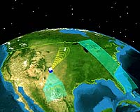
London UK (SPX) Mar 21, 2007 DMC International Imaging plans to launch a high-resolution optical imaging satellite named UK DMC-2 in 2008 to provide continuous Continent-level imaging with direct downlink of data to customer's ground stations. At just 120 kg, UK DMC-2 will be a very capable low cost Earth Observation (EO) satellite, carrying a higher-resolution (22 metre) multi-spectral DMC imager with an ultra-wide 660km imaging swath. The enhanced micro-satellite will be able to image continuously while broadcasting data in real-time to licensed ground stations. UK DMC-2 will be launched into the existing international Disaster Monitoring Constellation (DMC) with Deimos-1, built by Surrey Satellite Technology Ltd (SSTL) for Deimos Imaging SL, Spain. The 2 new generation DMC satellites will be coordinated with the 5 existing DMC satellites to provide data continuity and a new level of imaging output. The rapid revisit capability of the constellation is especially valuable for remote sensing applications that monitor fast changing phenomena such as fires, floods and crops. It also covers large areas quickly including the Amazon Basin, Australia, and Europe, providing the capability for multi-season coverage of major agriculture. David Hodgson, Managing Director DMCii, commented: "The next generation of DMC will serve our existing and new customers with higher resolution imagery and allow high frequency continent-wide environmental monitoring. The commercial success of the DMC demonstrates the advantage of the small satellite constellation approach to data supply and is the result of DMCii tailoring services to the individual needs of customers." DMCii works with the Members of the DMC to coordinate international commercial imaging campaigns, and coordinates rapid disaster response through the International Charter: Space and Major Disasters. DMCii's extensive calibration and process development programme generates high quality products to meet the demanding requirements of many remote sensing applications from precision agriculture to illegal logging. DMC International Imaging Ltd. (DMCii) is a UK company that supplies satellite imagery products and services to a wide range of international customers. DMCii supplies programmed and archived optical satellite imagery from the multi-satellite Disaster Monitoring Constellation (DMC). DMCii works with customers to tailor a supply service to meet specific customer and application needs. DMC images are used in a wide variety of commercial and government applications including agriculture, forestry and environmental mapping. DMC imagery is used extensively by organisations such as the European Commission, Brazilian Space Agency, United Nations, and the US Geological Survey. The small satellites of the DMC provide daily revisit combined with an unmatched 660km imaging swath width for frequent broad area coverage. Multispectral image products feature a pixel ground sample distance (GSD) of 32-metres today and 22-metres from 2008. DMCii's panchromatic image products feature a very high-resolution 4-metre pixel GSD. All DMC images are calibrated and processed to a variety of product levels according to customer requirements. DMCii provides imagery from satellites it owns and operates, UK-DMC and UK-DMC2 (2008) and also coordinates the commercial activity of the DMC satellite constellation. The DMC is independently owned and operated by a cooperating consortium of organisations representing member nations:
+ Centre National des Techniques Spatiales. Algeria The DMC Consortium members work together through DMCii for commercial sales and for collaborative Earth Observation campaigns. DMCii coordinates the DMC for humanitarian use in the event of major international disasters. Working in partnership with the UK British National Space Centre (BNSC) DMCii and the DMC Consortium members, DMCii provides services and imagery to the International Charter: "Space and Major Disasters". DMCii provides 24-hour emergency on call officer services and, in the event of a major disaster, tasks the global fleet of satellites made available by the world's space agencies. DMCii uses its expertise to select appropriate satellites for individual disaster circumstances. DMC imagery is supplied to organisations such as the United Nations, and the US Geological Survey during disasters such as Tsunami, Forest Fires and Flooding. DMCii was formed in October 2004 and is a wholly-owned subsidiary of the world leader in small satellite technology, Surrey Satellite Technology Ltd. SSTL designed and built the DMC with the support of the BNSC and in conjunction with the DMC member nations Algeria, China, Nigeria, Turkey and the UK. Related Links Making money out of watching earth from space today Earth Observation News - Suppiliers, Technology and Application
 Paris, France (ESA) Mar 21, 2007
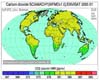
Based on three years of observations from the SCIAMACHY instrument aboard ESA's Envisat, scientists have produced the first movies showing the global distribution of the most important greenhouse gases - carbon dioxide and methane - that contribute to global warming. |
|
| The content herein, unless otherwise known to be public domain, are Copyright Space.TV Corporation. AFP and UPI Wire Stories are copyright Agence France-Presse and United Press International. ESA Portal Reports are copyright European Space Agency. All NASA sourced material is public domain. Additional copyrights may apply in whole or part to other bona fide parties. Advertising does not imply endorsement, agreement or approval of any opinions, statements or information provided by Space.TV Corp on any Web page published or hosted by Space.TV Corp. Privacy Statement |