|
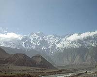
Ithaca NY (SPX) May 08, 2007 For nearly a decade and a half, Cornell geologist Larry Brown has been leading an international seismic profiling effort in Tibet, using explosions to probe the deep earth and discover how continents formed millions of years ago. The project, called INDEPTH -- for International Deep Profiling of Tibet and the Himalayas -- has gone through several stages and now is a major international collaboration among scientists from the United States, China, Germany, Canada and, most recently, Ireland. The National Science Foundation recently renewed funding for the project with a grant of $1.3 million to Cornell to finish the survey. Brown, professor of earth and atmospheric sciences, has been leading the project across the Tibetan plateau, located in the southwestern corner of China, since its inception in the early 1990s. Tibet is one of the world's best examples of what happens when continents smash together, Brown explained, because of its famously high elevation and sprawling terrain. The Himalayas are thought to be have formed when the Indian continent slammed into Asia beginning about 50 million years ago. The ultimate goal, according to Brown, is to piece together what happens when continents collide to form supercontinents like Eurasia. A common theory is that the Tibetan Plateau formed when India was pushed under Asia from the south. "We'll be testing the hypothesis that, in fact, Asia is also being stuffed under the northern part of the plateau," Brown said. In order to do that, scientists must understand the geometry of rock layers under the Earth's surface. The researchers use echo sounding, which is the same basic technology used to map the ocean bottom and explore for oil and gas. In Tibet, the scientists set up explosions that generate sound waves, whose echoes off the deep rock layers are recorded and analyzed. This allows an "acoustic photograph" to be taken as deep as 100 miles, but typically between 20 and 30 miles deep, said Brown, whose current work also involves deep imaging of major earthquake faults in Taiwan and an active volcano on the Caribbean island of Montserrat. Future targets of Brown's work include sites in Brazil, Africa, Madagascar and India. Related Links Cornell University Tectonic Science and News
 Bell House MS (SPX) Apr 16, 2007
Scientists have found one of the largest fields of seafloor vents gushing super-hot, mineral-rich fluids on a mid-ocean ridge that, until now, remained elusive to the ten-year hunt to find them. |
|
| The content herein, unless otherwise known to be public domain, are Copyright Space.TV Corporation. AFP and UPI Wire Stories are copyright Agence France-Presse and United Press International. ESA Portal Reports are copyright European Space Agency. All NASA sourced material is public domain. Additional copyrights may apply in whole or part to other bona fide parties. Advertising does not imply endorsement, agreement or approval of any opinions, statements or information provided by Space.TV Corp on any Web page published or hosted by Space.TV Corp. Privacy Statement |