 |
New York NY (SPX) Jul 30, 2010 Augmentra has announced that its award-winning ViewRanger GPS outdoors navigation system is now available as a Smartphone app for the Apple iPhone (3g, 3gs and 4), iPad, and Android devices. Designed for off-road - and offline - navigation, ViewRanger is the perfect companion for outdoor enthusiasts including campers and hikers, as well as field-based applications such as search-and-rescue. Among its many features, ViewRanger offers "BuddyBeacon," which allows customers to publish their whereabouts to Facebook or Twitter in real time (cellular data service is required). The ViewRanger Smartphone app is now available to the U.S. market from $4.99 per download on Android Market, or $19.99 with included premium mapping on Apple iTunes Unlike costly dedicated GPS receivers that only offer basic map displays with limited information and no connectivity, ViewRanger is the first solution to offer access to high quality National Geographic U.S. maps stored on the phone, off-road GPS location and tracking navigation, and location-based content sharing - including a Facebook application - in an integrated, easy to use mobile application across a wide range of devices. Designed around a natural and intuitive display, ViewRanger is a unique tool that provides information about your immediate surroundings by transforming your iPhone, iPad, Android or Symbian-based Smartphone into a fully featured trail navigation system that works even without a cell phone signal. The app is ideal for tourists, walkers, cyclists, mountain bikers, horse riders, geocachers, river boaters - or anyone who enjoys the outdoors. In addition, ViewRanger offers a built-in, real-time tracking feature called BuddyBeacon. BuddyBeacon uses the cellular network (where available) to emit a tracking signal so campers and other outdoor adventurers can provide information on their real time location to friends and family. Documented as a proven tracking solution, a number of organizations use ViewRanger to aid in their search and rescue efforts. "Since we launched our off-road GPS app on the Symbian platform two years ago, its adoption across Europe by walkers, hikers, bikers and other outdoor sports people has been enthusiastic and has received a great response," says Craig Wareham, CEO of Augmentra. "Now that it's available on popular U.S. operating systems for Android and iPhone, we anticipate consumers in the U.S. will embrace our offering as well."
National Geographic Partners with ViewRanger Dan Ortiz, Vice President, Products, Marketing and Operations for National Geographic Maps, comments that, "We are excited to offer detailed topographic maps of the United States to a growing number of smartphone users. There is a generation of people that have grown up with vehicle sat-navs and internet-based maps who may rarely use topographic maps. ViewRanger GPS captures this audience, and by making it easy to follow a topographic map on their phone, it will allow them to venture into the outdoors with confidence."
ViewRanger GPS US Availability The Apple iTunes version comes complete with $19.99 worth included credit that can be used to download National Geographic Topo! maps directly to your cell phone. Whereas, the Android application comes with access to a range of worldwide open sourced maps that can be enhanced with the in-app purchase of more detailed premium topographic maps, including those produced by National Geographic in USA or 12 European Map agencies. ViewRanger GPS delivers the best possible experience for outdoor enthusiasts. The application utilizes the phone's GPS and web connectivity to allow our customers to plot their routes and consult maps from virtually any country around the globe. Additionally, the service includes anywhere access to a growing trail marketplace of downloadable free and paid-for guided routes. The powerful navigation software and simple to use GPS interface allows the Android or Apple device to be used as a reliable and precise outdoors GPS navigator. ViewRanger GPS can be used even when there is no mobile coverage, as the maps are cached onto the handset. The application also includes a sports computer to allow users to record their performance metrics. ViewRanger's combination of features make it the application of choice for all manner of outdoor recreational activities - on land, air, or water. It has a proven track record and is reliable enough to be used by many of Great Britain's search and rescue teams. When used on the iPad, the ViewRanger GPS app uses the big screen capabilities of the product to display the map details on two-thirds of the screen and the remaining third for displaying Organizer and other supporting details to radically enhance the user experience in route planning and checking.
Share This Article With Planet Earth
Related Links ViewRanger GPS GPS Applications, Technology and Suppliers
 Navigation That Makes Sense Of Life's Twists And Turns
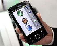
Sydney, Australia (SPX) Jul 30, 2010 Garmin-Asus and Optus have announced a smartphone designed for those looking for a true 'all-in-one' navigation experience to help make sense of life's twists and turns. The Garmin-Asus A50, available exclusively in Australia to Optus customers, is designed to provide a user-friendly, intuitive and consistent mobile navigation experience for consumers. The Garmin-Asus A50 brings together t ... read more |
|
| The content herein, unless otherwise known to be public domain, are Copyright 1995-2010 - SpaceDaily. AFP and UPI Wire Stories are copyright Agence France-Presse and United Press International. ESA Portal Reports are copyright European Space Agency. All NASA sourced material is public domain. Additional copyrights may apply in whole or part to other bona fide parties. Advertising does not imply endorsement,agreement or approval of any opinions, statements or information provided by SpaceDaily on any Web page published or hosted by SpaceDaily. Privacy Statement |


 del.icio.us
 Digg
Digg Reddit
 YahooMyWeb
 Google