|
USINFO Staff Writer Washington DC (SPX) Apr 16, 2007 Over the 35 years that U.S. Landsat Earth-observation satellites have collected images of the planet from space, scientists around the world have put the data to work in a range of applications, from agriculture and land-use planning to ecological forecasting and disaster management. The program - a shared responsibility of NASA and the Department of the Interior's U.S. Geological Survey (USGS) - also has played a role in helping those in the poorest and most resource-challenged nations harness the power of technology, including remote sensing, to make the best, most sustainable use of their natural environment. Since the 1980s, the U.S. Agency for International Development (USAID) has provided core funding to the International Program at the USGS Center for Earth Resources Observation and Science (EROS) in South Dakota for projects that use remotely sensed data to address resource management, land-cover change, monitoring and early warning systems in countries around the world.
Help With Famine And Floods USAID established the famine early warning system (FEWS) in 1986 to help prevent famine in sub-Saharan Africa by giving decision makers specific information based on remote sensing about potential famine conditions. In 2000, the FEWS Network was formed to establish more effective, sustainable, African-led food security and response planning networks to reduce the vulnerability of at-risk groups to famine and floods. The USGS EROS Center, NASA and the National Oceanic and Atmospheric Administration (NOAA) are among the contributing partners. In 2003, USAID began funding NASA to establish SERVIR, a Web-based visualization and monitoring system for Central America and Mexico that makes satellite images and geospatial information available to decision makers, students, business communities and the public. (See related article.) The system has been used for forecasting weather, monitoring fires, determining populations at risk for flooding and landslides, monitoring red tides for fisheries, analyzing climate change and mapping land cover. "From disaster response to long-term development planning, these Earth observation technologies improve our ability to understand the integrated nature of the work we do around the world, and thus be more effective," said Carrie Stokes, a geospatial information technology adviser at USAID. "We can see more holistically how projects in different sectors such as economic growth, agriculture, natural resource management, health and governance can be linked to reinforce each other," she added. "Building the capacity of people to use geospatial technologies for addressing a host of issues ranging from food security, urban development, biodiversity conservation and climate change is therefore a priority for us." The system uses many kinds of remotely sensed data, but Landsat imagery forms the basis for each country's national map. USAID also funds the West Africa Land Use and Land Cover Trends Program, an effort by USGS EROS Center scientists to work with partners in 14 countries in that region to map and quantify changes in the landscapes over the past 40 years.
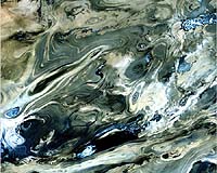
Mapping Changes Over Time Gray Tappan is a geographer with Science Applications International Corp., a contractor for the USGS EROS Center, who works on the land-cover trends program. The effort is a challenge, he said in an April 11 USINFO interview, because of the vast land area involved and the difficulty of piecing together images from different sources. "We're looking at four points in time - 1965, 1975, 1985 and 2000," he said. "It's like making four separate maps, then we compare them and from that we derive changes. It gives us a visual graphic of the land resources and the way they were 40 years ago, or 20 years ago, and gives us statistics about the areas of forest, wetlands, urban areas and agriculture." In West Africa, EROS scientists have been working since 1988 with African partners at the AGRHYMET (for agriculture, hydrology and meteorology) Regional Center in Niamey, Niger, to help them build remote-sensing capacity. In the maps, Tappan said, "we're seeing the slow but sure expansion of agricultural lands into forested lands and savannahs, so natural vegetation is losing ground to agriculture. It is a concern - we're seeing a fairly rapidly changing environment, driven mainly by human activity." The next step, he said, "is to provide this very graphic evidence to high-level policymakers in each country and begin a dialogue. We can also use computers to show what those landscapes might look like in 2020 or 2050. That kind of gets their attention." In another land-cover-change project in Niger, farmers improved land-clearing and farming practices and adopted better soil and water conservation and agroforestry practices. This led to a regrowth of trees and shrubs that surpasses the number that existed 30 years ago and has a positive impact on tens of thousands of rural households. This outcome was so amazing that even the Nigeriens were skeptical, Tappan said, until remote sensing imagery "had a huge role in convincing first the Nigeriens and high-level government officials, then the world beyond, that such resources can be restored." This is the sort of success story that new technologies like remote sensing can help duplicate in Africa and elsewhere, according to Tappan. "More than any other satellite out there," he said, "it's Landsat that allows us to do this, because Landsat was the first satellite designed to help us study Earth land resources." Related Links USGS EROS Center FEWS NET SERVIR USINFO Making money out of watching earth from space today Earth Observation News - Suppiliers, Technology and Application
 Silver Spring MD (SPX) Apr 13, 2007
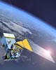
NASA and NOAA Wednesday announced a plan to restore a key ozone layer climate sensor to the National Polar-orbiting Operational Environmental Satellite System (NPOESS) program. The Ozone Mapping and Profiler Suite (OMPS) Limb will be returned to NPOESS Preparatory Project (NPP) satellite set to launch in 2009. |
|
| The content herein, unless otherwise known to be public domain, are Copyright Space.TV Corporation. AFP and UPI Wire Stories are copyright Agence France-Presse and United Press International. ESA Portal Reports are copyright European Space Agency. All NASA sourced material is public domain. Additional copyrights may apply in whole or part to other bona fide parties. Advertising does not imply endorsement, agreement or approval of any opinions, statements or information provided by Space.TV Corp on any Web page published or hosted by Space.TV Corp. Privacy Statement |