 |
Greenbelt MD (SPX) Sep 09, 2010 Their emergencies happened hundreds, if not thousands, of miles from one another, but the captain whose vessel had become disabled near Kamalino, Hawaii, the pilot who crashed onto the Knik Glacier near Anchorage, Alaska, and the hiker who suffered a compound fracture while hiking near Merritt, Washington, all share a common experience: They were plucked to safety in the weeks leading up to the Labor Day weekend due to NASA technology. With these rescues, the total number of people saved so far this year because of technologies NASA created for the international Search and Rescue Satellite-Aided Tracking (SARSAT) program is 186. "We had 195 saves last year in the U.S.," said LT Shawn Maddock, the SARSAT Operations Support Officer for the National Oceanic and Atmospheric Administration (NOAA), the agency that manages the SARSAT program in the U.S. "We're on pace to exceed that number this year." "That's the beauty of this program," said NASA Search and Rescue Mission Manager Dave Affens. In the 30 years since the system began operations, it has saved more than 28,000 lives worldwide and 6,420 in the U.S. "Our motto here is 'taking the search out of search and rescue,' so we want to reduce that part to a minimum," he added. Although Affens takes personal pleasure knowing that his work contributed to thousands of lives saved, perhaps the one rescue that he believes most clearly demonstrates the value of space-based search and rescue system is the one involving 16-year-old Abby Sunderland, who was saved in June after floating helplessly in the Indian Ocean about 2,000 miles from Madagascar after a violent storm had damaged her 40-foot vessel, Wild Eyes. "Without NASA technology, she may have lost her life. This case was more interesting than most because we contributed to every aspect of it," Affens said. In the ultimate display of NASA spin-off technology, Abby's life was changed with a small yellow device the size of a BlackBerry. Fortunately, she was carrying a MicroPLB Type GXL handheld device - developed under a NASA Small Business Innovation Research (SBIR) program award to Microwave Monolithics Inc. (MMInc.) in Simi Valley, California. The company had given Abby the device before she tried to break the record of sailing non-stop around the world, previously held by her older brother. NASA had provided Microwave Monolithics with the specifications to design the beacon, which relayed her distress signal to a SARSAT satellite, 22,500 miles away in space. When Abby activated the beacon, the satellite, equipped with NASA-developed repeater technology, then relayed the signal to the U.S. via the international satellite-aided search and rescue network now comprised of 40 participating nations. Eight minutes later, the U.S. Coast Guard's Pacific Area Command in Alameda, California, contacted her parents using information she provided when she registered her beacon with NOAA. And less than an hour later, two NOAA weather satellites, launched by NASA, used NASA technology to pinpoint her location. "We developed the concept of detecting distress signals by the satellite, relaying it to ground stations where the locations were calculated. We then launched the distress-detection device on a NOAA weather satellite, tested the concept, and approved the system for operational use," Affens explained. Ultimately, a French fishing vessel, which was 400 miles from Abby's location when the distress signal was detected, was directed to her location to perform the rescue. Affens and his team are now developing new technology to further take the "search out of search and rescue" with new technology that is sure to increase the number of rescues and lives saved in which SARSAT has assisted, he said. Engineers at NASA's Goddard Space Flight Center in Greenbelt, Maryland, along with NOAA, the Coast Guard, and the Air Force, are developing a new search and rescue system that will detect and locate distress signals from beacons in less than five minutes. The current system, which places repeaters on weather satellites, can actually take up to an hour or more to locate the distress signal depending on the position of the satellite. The Distress Alerting Satellite System, or DASS, will be more efficient because the repeater technology will be placed on the Air Force's Global Positioning System (GPS), instead of NOAA weather satellites. Using the constellation of 24 GPS spacecraft operating in mid-Earth orbit, "we would be able to identify distress signals faster and with a greater level of precision," Affens said. The new GPS-based system is now being tested. Currently 10 of the 20 GPS satellites are flying the proof-of-concept DASS equipment and an additional 12 are planned. Goddard is testing the technology before transitioning to a final system after 2015, which will be deployed on the Air Force's Block III GPS satellites. "The bottom-line here is that within one minute, we'll know where the distress signals come from," said Mickey Fitzmaurice, a space systems engineer for NOAA's SARSAT program. "It is the future."
Share This Article With Planet Earth
Related Links NASA Search And Rescue Office GPS Applications, Technology and Suppliers
 Three More GLONASS Satellites Put Into Orbit
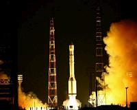
Moscow, Russia (RIA Novosti) Sep 03, 2010 Russia's Proton-M carrier rocket put three GLONASS satellites into orbit on Thursday, a spokesman for the Russian Space Forces said. The Proton-M rocket blasted off from the Baikonur space center in Kazakhstan at 4:53 Moscow time (0:53 GMT). "The launch and flight of the carrier rocket, as well as the separation of the satellites, took place on schedule," Alexei Zolotukhin said. ... read more |
|
| The content herein, unless otherwise known to be public domain, are Copyright 1995-2010 - SpaceDaily. AFP and UPI Wire Stories are copyright Agence France-Presse and United Press International. ESA Portal Reports are copyright European Space Agency. All NASA sourced material is public domain. Additional copyrights may apply in whole or part to other bona fide parties. Advertising does not imply endorsement,agreement or approval of any opinions, statements or information provided by SpaceDaily on any Web page published or hosted by SpaceDaily. Privacy Statement |


 del.icio.us
 Digg
Digg Reddit
 YahooMyWeb
 Google