 |
Greenbelt MD (SPX) Feb 09, 2011 Queensland, which is still trying to recover from earlier widespread flooding as a result of above-normal rainfall due to La Nina and previous tropical cyclone activity, just received a direct hit on the northeast coast by Yasi, one of the most powerful cyclones to strike the region in decades. Data from NASA and JAXA's TRMM satellite measured Queensland's intense rainfall from space. Cyclone Yasi, a massive storm, made landfall along the northeast coast of Queensland as a powerful Category 5 storm on the Australian Bureau of Meteorology's cyclone intensity scale (equivalent to a strong Category 4 storm on the U.S. Saffir-Simpson scale) midway between Cairns and Townsville, near to where Cyclone Tasha made landfall back in late December. After making landfall, Yasi continued to move west-southwest across central Queensland and on into the southeast corner of the Northern Territory deep within the central part of the country. The Tropical Rainfall Measuring Mission satellite (known as TRMM) was launched back in 1997 with the primary purpose of measuring rainfall in the Tropics from space. For increased coverage, TRMM can be used to calibrate rainfall estimates from other satellites. The TRMM-based, near-real time Multi-satellite Precipitation Analysis (TMPA) at the NASA Goddard Space Flight Center in Greenbelt, Md. is used to monitor rainfall over the global Tropics. TMPA rainfall totals were calculated for the period from January 28 to February 4, 2011 for northeastern Australia in association with the passage of Cyclone Yasi. Despite the fact that Cyclone Yasi was both a large and intense Category 5 storm, the rainfall totals are not very high, sparing the region from more massive flooding. TRMM showed that most of central Queensland received on the order of 50 to 100 mm (~2 to 4 inches) of rain. That's because one of the biggest contributors to tropical cyclone rainfall is how fast the storm is moving. Yasi moved rapidly across the region leaving little time for the rain to accumulate. The heaviest rain amounts occurred over coastal regions. Approximately 100 to just over 150 mm (~4 to 6 inches) fell right along the northeast coast of Queensland where the cyclone made landfall. Another area of heavier rain with similar amounts extends inland from the southern Gulf of Carpentaria where the storm's large clockwise circulation drew in additional moisture off the warm waters.
Share This Article With Planet Earth
Related Links Goddard Space Flight Center Earth Observation News - Suppiliers, Technology and Application
 A Snowy US Panorama By Satellite
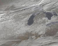
Greenbelt MD (SPX) Feb 09, 2011 Last week 30 U.S. states were affected by a massive winter storm. This week satellite images created by NASA provide a snowy panorama of that fallen snow. The Geostationary Operational Environmental Satellites (GOES) that cover the U.S. weather, GOES-11 and GOES-13 are operated by NOAA, and the NASA GOES Project at NASA's Goddard Space Flight Center in Greenbelt, Md. creates images and ani ... read more |
|
| The content herein, unless otherwise known to be public domain, are Copyright 1995-2010 - SpaceDaily. AFP and UPI Wire Stories are copyright Agence France-Presse and United Press International. ESA Portal Reports are copyright European Space Agency. All NASA sourced material is public domain. Additional copyrights may apply in whole or part to other bona fide parties. Advertising does not imply endorsement,agreement or approval of any opinions, statements or information provided by SpaceDaily on any Web page published or hosted by SpaceDaily. Privacy Statement |


 del.icio.us
 Digg
Digg Reddit
 YahooMyWeb
 Google