|
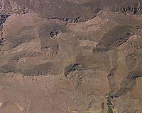
Washington DC (SPX) May 01, 2008 Policymakers, potential private investors, and the public received valuable new information today to help identify fault lines and the potential location of undiscovered water, oil and gas, and non-fuel mineral resources in Afghanistan. Data were collected by U.S. Geological Survey scientists, who flew over Afghanistan and conducted an airborne geophysical and photographic survey of the country. The survey data has been unveiled at The Embassy of Afghanistan in Washington, D.C. "Today we are proud to host jointly with the USGS the unveiling of the airborne geophysical and photographic survey of Afghanistan which will provide us with key data to gauge the natural resources that Afghanistan has," said Ambassador of Afghanistan to the United States Said T. Jawad. "The survey data being revealed here today will help identify fault lines to assess any potential hazard risks as well as the potential location and quantity of undiscovered water, oil and gas, and non-fuel mineral resources, providing invaluable new information to present to both public and private stakeholders as we all work together toward the rebuilding of Afghanistan. "Afghanistan has significant natural resource potential, but much of the country's potential remains unknown," said USGS Director Mark Myers. "The geophysical survey provides objective, unbiased information and will enable scientists to better define areas for future exploration and development." Scientists collected aerial photographs and geophysical data, which includes aeromagnetic and gravity data. Researchers combined the geophysical data with data from previous studies to create a magnetic anomaly map and a gravity anomaly map of Afghanistan. Airborne magnetic surveys provide a way to see through surface layers, such as sand, vegetation and water. They are a powerful tool for documenting the distribution and relative abundance of magnetic minerals in rocks - information that can help with mineral and petroleum exploration, tectonic interpretations, and seismic hazard assessments. Airborne gravity surveys help identify igneous rocks (rocks produced through intense heat) of interest for mineral resource studies, sedimentary basins for petroleum and water resource studies, and linear features for seismic hazard studies. The aerial photographs have many geologic and civil uses. They can help with the inventory and planning of civil infrastructure and agricultural resources and the development of detailed maps. In this effort, USGS scientists worked cooperatively with the Naval Research Laboratory, Afghanistan Geological Survey, Afghanistan Head Office for Geodesy and Cartography, personnel from the NRL Scientific Development Squadron ONE (VXS-1), Afghanistan Ministry of Mines and Industry, and the Canadian Forces Mapping and Charting Establishment. The airborne geophysical survey was flown during the summer of 2006. The Islamic Republic of Afghanistan commissioned the USGS to conduct this survey to assist in the reconstruction efforts of Afghanistan and to complement the resource assessments coordinated by the U.S. Agency for International Development. The USGS has also been working with the government of Afghanistan to provide a preliminary non-fuel mineral resource assessment of the nation issued on November 13, 2007, an earthquake hazards assessment released on May 30, 2007, and an oil and gas resources assessment of the nation issued in March 2006. Related Links USGS projects in Afghanistan Bringing Order To A World Of Disasters A world of storm and tempest When the Earth Quakes
 Washington (AFP) April 28, 2008
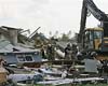
A tornado ripped through southeastern Virginia on Monday, causing about 200 injuries and damaging homes, authorities said. |
|
| The content herein, unless otherwise known to be public domain, are Copyright Space.TV Corporation. AFP and UPI Wire Stories are copyright Agence France-Presse and United Press International. ESA Portal Reports are copyright European Space Agency. All NASA sourced material is public domain. Additional copyrights may apply in whole or part to other bona fide parties. Advertising does not imply endorsement, agreement or approval of any opinions, statements or information provided by Space.TV Corp on any Web page published or hosted by Space.TV Corp. Privacy Statement |