 |
Bergen, Norway (ESA) Jul 01, 2010 Today, a focus at ESA's Living Planet Symposium is on the innovative SMOS mission, which recently became operational. Early results are proving very encouraging with its first observations due to be released in early July. ESA's Soil Moisture and Ocean Salinity (SMOS) satellite was launched in November to gather data on moisture in the surface layers of soil and salt in the surface of the oceans. SMOS will improve our understanding of the water cycle and help advance weather and climate studies. SMOS has completed an intense programme of calibration and commissioning and, in May, it formally began its operational life delivering data. Although it is still early days, scientists and users are very impressed with the first snapshots of 'brightness temperature' - the microwave radiation emitted from Earth's surface. ESA's Mission Manager, Susanne Mecklenburg said, "We still have some way to go before the full soil moisture and ocean salinity data products are available, but the brightness temperature data we have been working on for the past months clearly demonstrate what this advanced mission has to offer." The satellite carries an innovative sensor to image brightness temperature. As key observables, these images are used as input to derive global maps of soil moisture and ocean salinity. Given the success of the mission so far, the maps are expected to be available by the autumn. To test the usefulness of SMOS data for numerical weather prediction, data are also being delivered, within three hours of sensing, to meteorological centres such as the European Centre for Medium-Range Weather Forecasts. In a few months, global maps of soil moisture with an accuracy of 4% and 50 km resolution - the same as being able to detect a teaspoon of water in a handful of soil - will be available, and maps of ocean salinity down to 0.1 'practical salinity units' - equivalent to a gram of salt in 10 litres of water - averaged over 10 to 30 days and areas of 200 x 200 km. While users await the full results, the mission's usefulness is already being shown: in early May, SMOS picked up clear differences in soil moisture as heavy rains hit Tennessee and Kentucky, USA, and the subsequent drying period. Yann Kerr from the Centre d'Etudes Spatials de la Biosphere said, "The brightness temperature data currently being delivered by SMOS are better than expected." "The user community is very much looking forward to the full products that will not only advance our understanding of Earth processes, but also have many practical applications for water management, weather forecasting, and flood and drought prediction." The data for ocean salinity are also encouraging. Nicolas Reul from the French Research Institute for Exploitation of the Sea commented that, "We are now generating composites of sea-surface salinity maps from SMOS data." "Measurements taken in situ from floats show that SMOS data are to within 0.5 psu globally, and 0.4 psu in the tropics - even though the data has not gone through full processing." While there are still a few months to go before SMOS delivers full soil moisture and ocean salinity products, which will be available free of charge for all users, the current release of brightness temperature data provides a taster of what is to come.
Share This Article With Planet Earth
Related Links Living PlanetSymposium Earth Observation News - Suppiliers, Technology and Application
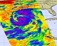 Alex Stirs Up The Gulf
Pasadena CA (JPL) Jun 30, 2010 Tropical Storm Alex, the first storm of the 2010 Atlantic hurricane season, continues to pick up steam as it crosses the western Gulf of Mexico. According to NOAA's National Hurricane Center, Alex is expected to approach the coast of northeast Mexico and southern Texas on Wed., June 30, and make landfall Wednesday night. The storm is expected to reach a peak intensity of 80 to 85 kno ... read more |
|
| The content herein, unless otherwise known to be public domain, are Copyright 1995-2010 - SpaceDaily. AFP and UPI Wire Stories are copyright Agence France-Presse and United Press International. ESA Portal Reports are copyright European Space Agency. All NASA sourced material is public domain. Additional copyrights may apply in whole or part to other bona fide parties. Advertising does not imply endorsement,agreement or approval of any opinions, statements or information provided by SpaceDaily on any Web page published or hosted by SpaceDaily. Privacy Statement |


 del.icio.us
 Digg
Digg Reddit
 YahooMyWeb
 Google