 |
|
by Staff Writers Munich, Germany (SPX) Aug 29, 2016
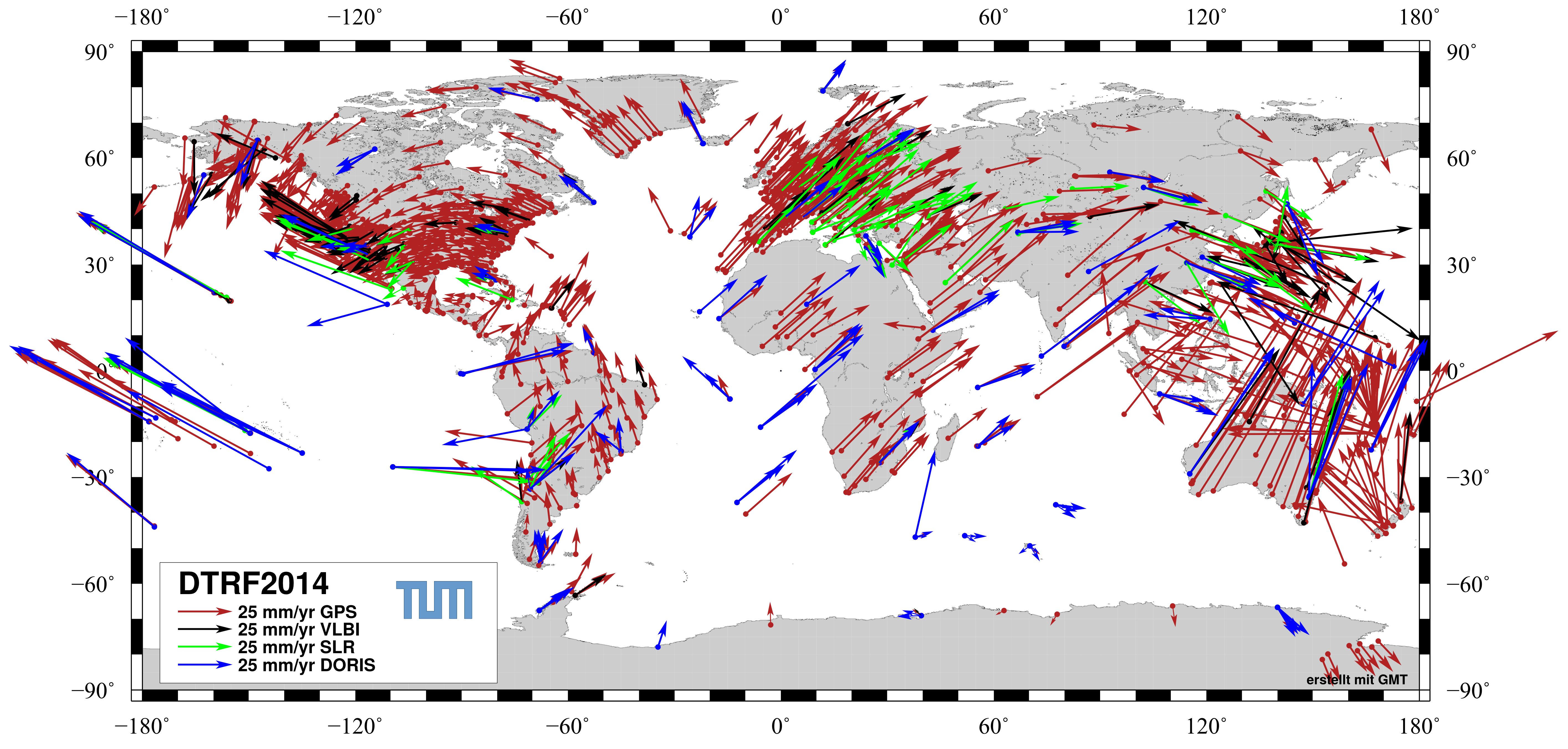
How many millimeters has the sea level risen? How fast are the continents moving? How big is the impact of high and low pressure areas on the altitude of landmasses? In order to answer these questions, measurements are being made around the clock at more than 1700 globally distributed observing stations. These data are then evaluated by researchers from the German Geodetic Research Institute of the Technical University of Munich (DGFI-TUM). Their new realization of the global reference system that has now been published, is so exact that it even allows to detect seasonal variations. Thanks to the modern smartphone, we always know where we are. The built-in GPS function even calculates the user's exact location in remote mountain valleys, using microwave signals from satellites that send information on their position to earth. But how do the satellites know their own position? "Everyday positioning wouldn't be possible without a highly complex reference system that requires constant updating," responds Prof. Florian Seitz, Director of the German Geodetic Research Institute of the TUM. His team has just published the DTRF2014, a brand new realization of the International Terrestrial Reference System. Constant updating is necessary because the earth is constantly changing. For example, each year Australia moves 6.9 centimeters to the northeast, while Hawaii drifts 7.1 centimeters to the northwest. Europe and America are moving away from one another; the Scandinavian countries, once weighed down by enormous sheets of ice, are now rising. "Measuring these movements exactly requires a highly precise reference system covering several decades. Here many dynamic processes have to be taken into account, for example the irregular rotational speed of the earth," Seitz explains.
With microwaves and lasers The observatory includes three radio telescopes for Very Long Baseline Interferometry (VLBI), which receive radio waves emitted by quasars. These measurements are required to detect changes in the position of our planet in space. In addition, two Satellite Laser Ranging (SLR) systems use powerful laser beams to observe the distance to satellites that reflect the laser light. This makes it possible to detect smallest movements of the ground station. In addition to these measurements several ground stations of the Global Navigation Satellite System (GNSS) receive data from GPS, Galileo and GLONASS. The three observation techniques VLBI, SLR and GNSS form the basis for the calculations of the DTRF2014. They are supplemented by the Doppler system DORIS (Doppler Orbitography and Radiopositioning Integrated by Satellite).
Seasonal variations "However, the process can't be completely automated," Seitz explains: "Corrections have to be made for sudden changes in position, for example those resulting from the earthquakes in Chile in 2010 or Japan in 2011. Otherwise this would result in incorrect inferences regarding future movements." Through careful analysis the TUM researchers could now, for the first time ever, include minute seasonal variations in the coordinates on the order of millimeters. These variations arise when persistent high-pressure areas exert pressure on the landmasses below them, or on the other hand when low-pressure areas relieve pressure on the land.
The future of the continents The results are of interest to geoscientists who can use the data to precisely model the movement of the earth's crust and to make inferences about the dynamics of the earth's interior. And the geodesists need the highly precise global coordinate system in order to measure the rising sea level - exactly down to the millimeter. "More than anything the system creates a new basis for the positioning of satellites and thus improves the precision of all satellite-guided navigation systems," summarizes Seitz. Reference to dataset: Seitz, Manuela; Blobfeld, Mathis; Angermann, Detlef; Schmid, Ralf; Gerstl, Michael; Seitz, Florian (2016): The new DGFI-TUM realization of the ITRS: DTRF2014 (data). Deutsches Geodatisches Forschungsinstitut, Munich, Doi:10.1594/PANGAEA.864046.
Related Links Technical University of Munich (TUM) GPS Applications, Technology and Suppliers
|
|||||||||||||
|
|
| The content herein, unless otherwise known to be public domain, are Copyright 1995-2024 - Space Media Network. All websites are published in Australia and are solely subject to Australian law and governed by Fair Use principals for news reporting and research purposes. AFP, UPI and IANS news wire stories are copyright Agence France-Presse, United Press International and Indo-Asia News Service. ESA news reports are copyright European Space Agency. All NASA sourced material is public domain. Additional copyrights may apply in whole or part to other bona fide parties. All articles labeled "by Staff Writers" include reports supplied to Space Media Network by industry news wires, PR agencies, corporate press officers and the like. Such articles are individually curated and edited by Space Media Network staff on the basis of the report's information value to our industry and professional readership. Advertising does not imply endorsement, agreement or approval of any opinions, statements or information provided by Space Media Network on any Web page published or hosted by Space Media Network. General Data Protection Regulation (GDPR) Statement Our advertisers use various cookies and the like to deliver the best ad banner available at one time. All network advertising suppliers have GDPR policies (Legitimate Interest) that conform with EU regulations for data collection. By using our websites you consent to cookie based advertising. If you do not agree with this then you must stop using the websites from May 25, 2018. Privacy Statement. Additional information can be found here at About Us. |

 del.icio.us
 Digg
Digg Reddit
 Google