|
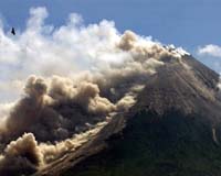
University Park PA (SPX) Jan 26, 2009 When volcanoes erupt, pinpointing the regions at high risk for lethal hazards and deciding whether or not to evacuate a resistant population comprise the most difficult problems faced by hazards managers. Now a team of volcanologists has a program that maps potential problem areas quickly, taking much of the guesswork out of decision making and evacuations. "We wanted to be able to predict the areas affected by pyroclastic flows from volcanoes," said Christina Widiwijayanti, post-doctoral fellow in geosciences. "Pyroclastic flows and surges are the phenomena that kill most people when volcanoes erupt." A pyroclastic flow consists of hot rocks, ash and superheated gases that rapidly flow down from the area of dome collapse on a volcano. Pyroclastic surges are similar, but less dense. They are a kind of hot ash hurricane that can escape the confines of river valleys. Both types of currents are dangerous and frequently lethal. "In many volcanic crises, a hazard map for pyroclastic flows and surges is sorely needed, but limited time, exposures or safety aspects may preclude fieldwork, and insufficient computational time or baseline data may be available for adequately reliable dynamic simulations of future pyroclastic flow or surge events," the researchers note in a paper published in the Bulletin of Volcanology, Online First. The researchers, working with Steve P. Schilling, U.S. Geological Survey Cascades Volcano Observatory, looked at an existing procedure created by Schilling called LAHARZ, a geographical information system (GIS) method intended to map hazard zones for volcano-induced mudflows. "The approach worked for water-saturated mud flows, we thought maybe it would work for hot pyroclastic flows," said Barry Voight, professor emeritus of geosciences. "So we looked at the eruption data and developed some new ways of forecasting areas of impact, particularly for the ash hurricanes." The researchers used data from eruptions of a variety of volcanoes including the Soufriere Hills Volcano, Montserrat; Mount Merapi, Indonesia; Mount Unzen, Japan, and Colima, Mexico to develop a predictive equation for mapping the hazard. The equation considered the cross sectional area of the flows, the area covered and the amount of material in the flow, and is embedded in the GIS. "What we are doing is looking at the volcano to see, for each valley system, how far the hot flows of rock and ash can come," said Dannie Hidayat, post doctoral fellow in geosciences. "We can outline the area of potential surge damage and this can be used by decision makers on whether to evacuate or to put people on high alert to evacuate." Widiwijayanti and Hidayat have personal interests in volcanoes having grown up in Indonesia in close proximity to dangerous erupting volcanoes. Indonesia has 129 active volcanoes. The slopes of Mount Merapi are the home of a quarter million people and Widiwijayanti's family home is within reach of Merapi ash falls. "Using this program, we can produce maps long before the eruption takes place and they can be kept on the shelf for immediate use, or we can produce maps as needed as soon as there is an indication of impending pyroclastic explosions," said Widiwijayanti. The program creates maps that outline where the rock and ash will flow for different prospective volumes of material expelled. The volumes are color coded. Also included are mapped lines that indicate the extent of the hot ashy surge for both high and low volumes. Currently, the program will map hazard zones for pyroclastic flows that go outward and down from the volcano's dome, but the researchers believe that it could also be applied to those pyroclastic eruptions that are column explosions, throwing up mixtures of rock, ash and gas into the air before they come down and form hot radial currents. "The topology data is available online at good resolution for worldwide sites, so anyone who has GIS can run the simulation," said Widiwijayanti. This method has already been used twice in eruption crises: once at Merapi in 2006 and in Montserrat in 2006-2009 to quickly and effectively create pyroclastic flow maps. "I expect this method to make a difference in volcano hazards mitigation," said Voight. "These maps can be created quickly, in a few days and e-mailed anywhere in the world. We do not need anyone on the ground to study the situation nor do we need a physics-based model to obtain robust curves. This approach saves time and saving time can save lives. We can now avoid being 'too little and too late' in our mitigation response." Related Links Penn State Bringing Order To A World Of Disasters When the Earth Quakes A world of storm and tempest
 Seattle (UPI) Nov 24, 2008
 Crew members of a research ship say they were surprised to find a volcano more than 10,000 feet underwater off the coast of Washington. |
|
| The content herein, unless otherwise known to be public domain, are Copyright Space.TV Corporation. AFP and UPI Wire Stories are copyright Agence France-Presse and United Press International. ESA Portal Reports are copyright European Space Agency. All NASA sourced material is public domain. Additional copyrights may apply in whole or part to other bona fide parties. Advertising does not imply endorsement, agreement or approval of any opinions, statements or information provided by Space.TV Corp on any Web page published or hosted by Space.TV Corp. Privacy Statement |