|
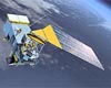
North Ryde, Australia (SPX) Jun 25, 2008 Jason-2, or the Ocean Surface Topography Mission (OSTM), is a joint venture between NASA's Jet Propulsion Laboratory, the US National Oceanic and Atmospheric Administration (NOAA), the French Space Agency (CNES) and the European Meteorology Satellite service (EUMETSAT). "There's plenty resting on this satellite in terms of where our ocean and climate science is going," says Dr David Griffin, an oceanographer from the CSIRO Wealth from Oceans National Research Flagship and a member of the international Science Team which advises on satellite altimeter missions. "Jason-2 provides a lifeline between space and some very significant science projects that are integral to our capabilities in understanding how the oceans are changing and particularly future ocean forecasting products," he says. With an orbit 1336 kilometres above the Earth's surface, Jason-2 will be one of three satellites equipped with special altimetry sensors to precisely measure sea level, and indirectly infer ocean heat content changes. This information is also important for: Australia's evolving ocean forecasting system, BLUElink; sea safety and offshore oil and gas operations; measuring global sea level rise; tracking large-scale ocean-atmosphere phenomena like El Nino and La Nina and marine mammals feeding in nutrient-rich ocean eddies; and forecasting currents for sports events such as the Sydney-Hobart yacht race. High quality satellite altimetry started with the TOPEX/Poseidon mission (1992-2005), and continued with Jason-1 (2001-to the present). The altimeters measure sea surface height, from which we can estimate the strength and direction of ocean currents and also map sea level rise. Australian scientists contribute to the science mission in a number of ways, including calibration of the sensors on board the satellite. CSIRO Marine and Atmospheric Research, in conjunction with the University of Tasmania, the Bureau of Meteorology's National Tidal Centre and Geoscience Australia has been running a calibration facility at Burnie (NW Tasmania) since 1992. This was enhanced by the deployment of a French transportable Satellite Laser Ranging (SLR) system at Burnie earlier this year. Burnie is the only absolute calibration site in the Southern Hemisphere. The other two main sites are off the coast of California, and in the Mediterranean Sea. The satellite will provide 95 per cent coverage of the world's ice-free oceans, repeating its coverage every 10 days and measuring sea surface height with an accuracy of about 3 centimetres. Australian science agencies using data from the new satellite include the Centre for Australian Weather and Climate Research - a partnership of CSIRO and the Bureau of Meteorology - and the Antarctic Climate and Ecosystem Cooperative Research Centre. Related Links Centre for Australian Weather and Climate Research (CAWCR) CSIRO Wealth from Oceans National Research Flagship Earth Observation News - Suppiliers, Technology and Application
 Washington DC (SPX) Jun 24, 2008
Today, the House Committee on Science and Technology's Energy and Environment Subcommittee continued its oversight of the National Polar-Orbiting Operational Environmental Satellite System (NPOESS). |
|
| The content herein, unless otherwise known to be public domain, are Copyright Space.TV Corporation. AFP and UPI Wire Stories are copyright Agence France-Presse and United Press International. ESA Portal Reports are copyright European Space Agency. All NASA sourced material is public domain. Additional copyrights may apply in whole or part to other bona fide parties. Advertising does not imply endorsement, agreement or approval of any opinions, statements or information provided by Space.TV Corp on any Web page published or hosted by Space.TV Corp. Privacy Statement |