|
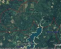
Moffett Field CA (SPX) Jan 29, 2009 NASA's satellite imagery, combined with high-resolution commercial imagery, is giving scientists new insight into the changing appearance of our planet on a regional scale, and whether it is due to human activity or extreme climate. Researchers from NASA Ames Research Center, Moffett Field, Calif., and California State University Monterey Bay, Seaside, Calif., analyzed several years of imagery data collected by the Moderate Resolution Imaging Spectroradiometer (MODIS) instrument aboard the NASA Terra satellite, and then fused these results with high-resolution commercial images to identify changes to local vegetative "green" areas. They found that regional land cover disturbances can be identified, most recently as wildfire-burned areas and extensive forest harvests. "This is the first application of its kind. NASA is beginning to take full advantage of using its daily satellite imagery data in tandem with the compelling visual detail and color images from commercial sources," said Chris Potter, lead author of the new study, published in the May 2008 Imaging Notes, a trade journal for the commercial satellite imaging companies. By using NASA MODIS to pinpoint changes in extensive areas of land cover, underlying commercial images are given unique, dynamic attributes, allowing consumers and land use planners to make better interpretations of areas showing remarkable changes in color and vegetation. Scientists found that between 1970 and 2005, California experienced a 75 percent increase in its population, resulting in rapid and extensive urbanization and loss of natural vegetative ground coverage. These urbanized areas expanded into irrigated prime farmland, fallow marginal farmlands and wildlands. Between 2001 and 2005, the MODIS images taken above an area of approximately 3,200 sq. miles, revealed continually shrinking green areas in California. The area studied included forests (46 percent), shrublands (29 percent) and herbaceous cover (7 percent). According to the MODIS time series analysis, the forests and shrublands showed most of the continual reduction in surface area. In contrast, about 200 square miles of the MODIS image area, less than one percent, showed signs of expanding vegetation green areas. Scientists focused on the shrinking green areas for the remainder of the study. By using high-resolution commercial images, scientists were able to examine in greater detail the Earth's diminishing vegetation coverage. The image analysis revealed a recent wildfire-burned area and extensive forest harvests near Lower Bear River Reservoir in Amador County, Calif.. Similar areas showed extensive forest cutting in the state's Mendocino, Butte, and Pulmas counties. NASA researchers will continue to explore use of image analysis to help show greater detail of the ever-changing appearance of Earth. "The use of satellite imagery has made the mapping of land cover changes possible on local and global scales, which has helped a variety of disciplines, including agronomy, urban planning, and forestry," said Potter. The study also appeared in the following peer-reviewed article: Potter, C., V. Genovese, P. Gross, S. Boriah, M. Steinbach, and V. Kumar, 2007, "Revealing land cover change in California with satellite data," EOS Transactions, American Geophysical Union, 88(26): 269-274. Download pdf version [3.9 Mb]. Related Links Terra at NASA Earth Observation News - Suppiliers, Technology and Application
 Brussels Belgium (SPX) Jan 29, 2009
This week in Brussels, the amendment to the EC-ESA GMES agreement was signed by Mr Jean-Jacques Dordain, the ESA Director General, and Mr Heinz Zourek, Director General of the European Commission's Directorate General for Enterprise and Industry. |
|
| The content herein, unless otherwise known to be public domain, are Copyright Space.TV Corporation. AFP and UPI Wire Stories are copyright Agence France-Presse and United Press International. ESA Portal Reports are copyright European Space Agency. All NASA sourced material is public domain. Additional copyrights may apply in whole or part to other bona fide parties. Advertising does not imply endorsement, agreement or approval of any opinions, statements or information provided by Space.TV Corp on any Web page published or hosted by Space.TV Corp. Privacy Statement |