 |
Greenbelt MD (SPX) Mar 17, 2011 NASA's Aqua and TRMM satellites are providing data to scientists about the Southern Atlantic Ocean Sub-tropical Storm Arani, a rare occurrence in the southern ocean. Rainfall data and cloud top temperatures revealed some heavy rain and strong thunderstorms exist in Arani as it continues to pull away from Brazil. NOAA's Satellite and Information Service classified Arani as a T1 on the Dvorak intensity scale which would indicate an estimated wind speed of about 29 knots (~33 mph). During the daytime on Tuesday, March 15 at 1820 UTC (2:20 p.m. EST) NASA's Tropical Rainfall Measuring Mission (TRMM) satellite flew over Sub-Tropical Storm Arani. TRMM rainfall data showed that the storm contained mostly moderate rainfall, falling at a rate between 20 and 40 millimeters (.89 to 1.57 inches) per hour. However, there were some areas of heavy rainfall in the north and eastern quadrants of the storm. The heavier rainfall was occurring at about 50 mm or 2 inches per hour. TRMM's Microwave Imager (TMI) and Precipitation Radar (PR) data were used in the image above to show rainfall near Arani. On Mar. 16 at 03:29 UTC (Mar. 15 at 11:29 p.m. EST) another of NASA's fleet of Earth science satellites flew over Sub-tropical Storm Arani and took its temperature. NASA's Aqua satellite captured an infrared image of Sub-Tropical Storm Arani's cold thunderstorm cloud tops in two areas of the storm. The Atmospheric Infrared Sounder (AIRS) instrument that flies aboard Aqua provided infrared readings of those cloud tops and showed that they were as cold as or colder than -63F/-52 C, and were areas of heavy rainfall. The strongest thunderstorms wrapped from the north, eastward to the south of the center of circulation, confirming the data from the TRMM satellite. Later on March 16, at 10:52 UTC (6:52 a.m. EST), the TRMM satellite again passed over Sub-Tropical Storm Arani and noticed it still had some strong thunderstorms and was producing heavy rainfall off the Brazilian coast. TRMM data was used to create a 3-D view of Sub-tropical Storm Arani's clouds, and it showed that there were very heavy thunderstorms in the eastern half of the storm. TRMM's Precipitation Radar showed that some of these powerful storms were reaching to heights of over 14 km (~8.7 miles) above the surface of the Southern Atlantic Ocean. Arani has the appearance of a tropical cyclone but has been classified as a subtropical cyclone. Subtropical cyclones are low pressure areas that develop with a cold core and transition to a warm core in the mid-levels of the troposphere, resembling a tropical cyclone. They more typically form outside of hurricane season (which is June 1 to Nov. 30 in the Northern Atlantic, for example). They also have broad wind patterns and that means that their maximum sustained winds are usually located farther from the center than a tropical cyclone. They also have no weather fronts linked to them, such as a typical low pressure area that brings summertime storms with an associated cold front. Subtropical cyclones can sometimes become tropical cyclones, and occasionally, tropical cyclones can become subtropical. Tropical cyclones are very rare in the Southern Atlantic Ocean. In 2004 a cyclone called Catarina formed in the South Atlantic and caused some controversy when it was classified as a hurricane by the United States' National Hurricane Center. Arani is over the open waters of the Southern Atlantic and continues to move east-southeast and farther away from Brazil.
Share This Article With Planet Earth
Related Links Goddard Space Flight Center Earth Observation News - Suppiliers, Technology and Application
 National Flooding Exercise Hones Use Of Satellites To Improve Disaster Mitigation
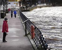
London, UK (SPX) Mar 17, 2011 Last week a team of space experts led by British company DMCii participated in a national flooding exercise, "Exercise Watermark", to determine how satellite imagery, satellite communications and satellite navigation could be used to improve UK emergency response. The team represented an ongoing project funded via the UK's Technology Strategy Board (TSB) as part of its contribution to the Europe ... read more |
|
| The content herein, unless otherwise known to be public domain, are Copyright 1995-2010 - SpaceDaily. AFP and UPI Wire Stories are copyright Agence France-Presse and United Press International. ESA Portal Reports are copyright European Space Agency. All NASA sourced material is public domain. Additional copyrights may apply in whole or part to other bona fide parties. Advertising does not imply endorsement,agreement or approval of any opinions, statements or information provided by SpaceDaily on any Web page published or hosted by SpaceDaily. Privacy Statement |


 del.icio.us
 Digg
Digg Reddit
 YahooMyWeb
 Google