|
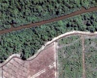
Kuala Lumpur (AFP) Dec 28, 2008 Malaysia is zooming in on forests with a satellite in order to fight illegal logging which its government says is harming the major timber exporting country, a report said Sunday. Darus Ahmad, deputy director-general with the Malaysian Remote Sensing Agency, said the "eye in the sky" programme was put in place in October. "There is always criticisms that our forests are diminishing," he was quoted as saying by the New Sunday Times newspaper. Darus said that using satellite images the authorities can establish a national forest inventory of the country's total area of forest cover. They can then check whether logging in a particular area is legal or not, he said, adding that the facility was currently available in the western peninsular part of Malaysia only. Darus also said the system can be used to prevent air pollution by detecting forest fires and illegal land clearing. In the 1990s alone, Malaysia lost more than 13 percent of its forests, with much of the deforestation on the island of Borneo, which it shares with Indonesia and Brunei. The World Wildlife Fund at the time estimated that illegally logged trees made up about one third of Malaysia's timber exports. Prime Minister Abdullah Ahmad Badawi last year pledged not to indiscriminately approve logging licences, amid mounting concern that clearances are threatening endangered species and tribal communities. Deputy Prime Minister Najib Razak, who also heads the National Forestry Council, later warned that illegal logging could undermine Malaysia. "It can jeopardise our efforts to preserve biodiversity, flora and fauna and have an impact on global warming. At the international level, illegal logging portrays a negative image of our country," he said. "It can harm our national economy as the timber industry produces 23 billion ringgit (6.8 billion dollars) worth of wood-based products a year," he added. The European Union market accounts for about 30 percent of Malaysia's annual timber exports. Related Links Earth Observation News - Suppiliers, Technology and Application
 London, UK (SPX) Dec 26, 2008
Infoterra Ltd, a leader in the provision of geospatial products and services, is working with Rallymaps, specialists in map delivery for major car rallies, to improve the efficiency of management and delivery of hundreds of maps for use by the teams in the Dakar Series. |
|
| The content herein, unless otherwise known to be public domain, are Copyright Space.TV Corporation. AFP and UPI Wire Stories are copyright Agence France-Presse and United Press International. ESA Portal Reports are copyright European Space Agency. All NASA sourced material is public domain. Additional copyrights may apply in whole or part to other bona fide parties. Advertising does not imply endorsement, agreement or approval of any opinions, statements or information provided by Space.TV Corp on any Web page published or hosted by Space.TV Corp. Privacy Statement |