 |
Santa Clara CA (SPX) Feb 20, 2008 Magellan introduces the latest addition to its MobileMapper GIS and mapping line of products - the MobileMapper 6. A rugged, waterproof, handheld GPS/GIS receiver, the MobileMapper 6 fulfills the requirements for low-cost, professional GIS field data collection. It fills a market gap in the data collection field between high-cost devices and consumer-grade products. It is expected to particularly appeal to forestry and other natural resource organizations, oil and gas, agriculture, utilities, government agencies, and businesses large and small that need a highly-rugged, robust GIS unit that can collect geographic data with 2-5 meter accuracy in real-time with SBAS corrections. The MobileMapper 6 is a Windows Mobile 6 open platform, unlike competing consumer-type units, it offers full compatibility with popular GIS software to enable companies to select and use the GIS software of choice. In addition, unlike PDA devices, the MobileMapper 6 is highly rugged for rough-and-tumble business applications. The MobileMapper 6 offers the professional features associated with more costly high-end GIS/GPS units, yet it is price-competitive with consumer-grade GPS. "The MobileMapper 6 is an economically, professional-grade GPS/GIS handheld receiver rugged-built for business applications," said Francois Erceau, general manager of Magellan Professional. "With its low-cost, lightweight rugged design, and the ability to run virtually all GIS software, we expect it to become a favorite of businesses both large and small." It comes standard with an integrated 2-megapixel camera that can take photos, which can be tagged with the GPS location and used as a point description data in any GIS application, such as Magellan's Mobile Mapping software, ESRI's ArcPad or other third-party software. It also includes a built-in microphone to record and replay voice notes to enrich the collected data. The MobileMapper 6 comes with Microsoft Windows Mobile version 6, along with a touch-screen and Bluetooth for wireless connectivity. The rugged design of the MobileMapper 6 is impact resistant and water- and dustproof for use in harsh and difficult field conditions. It is able to withstand a one-meter drop to solid ground and water submergence. Weighing less than 8 ounces (224 grams) and measuring approximately 5.7 in x 2.5 in x 1.1 in (14.6 cm x 6.4 cm x 2.9 cm), the MobileMapper 6 is lightweight and compact for easy, convenient use. It provides excellent autonomy with up to 10 hours of operation on a set of two AA alkaline batteries, easily exchangeable in the field. Data collection is enabled by 128 MB of non-volatile Flash data storage, and storage of large amounts of field date is made possible through a Secure Digital (SD) card slot that accepts SD cards with up to 4 GB of memory. Related Links MobileMapper 6 video GPS Applications, Technology and Suppliers
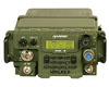 Rochester NY (SPX) Feb 20, 2008
Harris has been awarded a $25 million contract from the Brunei Ministry of Defence to supply tactical radios, accessories and other equipment to the Combat Net Radio replacement program of the Royal Brunei Armed Forces. The contract was awarded following competitive field trials. |
|
| The content herein, unless otherwise known to be public domain, are Copyright Space.TV Corporation. AFP and UPI Wire Stories are copyright Agence France-Presse and United Press International. ESA Portal Reports are copyright European Space Agency. All NASA sourced material is public domain. Additional copyrights may apply in whole or part to other bona fide parties. Advertising does not imply endorsement, agreement or approval of any opinions, statements or information provided by Space.TV Corp on any Web page published or hosted by Space.TV Corp. Privacy Statement |

