|
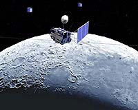
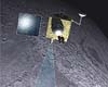
Tokyo, Japan (SPX) Oct 13, 2008 Astronomers are announcing that the precise gravity field of the lunar far side and the global lunar topography map were obtained by KAGUYA spacecraft. The report is being presented by Dr. Sho Sasaki of National Astronomical Observatory of Japan, in Ithaca, New York, to the 40th annual meeting of the Division for Planetary Sciences of the American Astronomical Society. The result is of great interest because it shows evidence of the difference of the interior and thermal history between the lunar far side and near side. The Japanese lunar explorer KAGUYA (SELENE) was launched on September 14th, 2007 by JAXA (Japan Aerospace Exploration Agency) and has been operated successfully more than one year. The aim of KAGUYA is to investigate important issues in the lunar science such as the interior structure of the Moon, especially the near/far side dichotomy. The interior of the Moon can be investigated from gravity data. KAGUYA found clear difference in gravity anomaly on the near side and far side of the Moon. This is evidence of a different evolutional history of the far side lunar interior from the near side. The lunar gravity field is estimated from radiowave tracking of spacecraft orbiting over the lunar surface. Since the far side of the Moon cannot be observed from the Earth, spacecraft over the far side of the Moon cannot be tracked directly. Previously the far side gravity of the Moon was obtained basically from the extrapolation of the spacecraft orbit over the near side. KAGUYA has two subsatellites (the relay subsatellite OKINA and VLBI subsatellite OUNA) for the far side gravity measurement. Since OKINA relays and transmits Doppler tracking signals of radiowave between the main satellite over the far side and the ground radio antenna, the orbits of the main satellite can be determined precisely. Thus we can obtain the accurate far side gravity field of the Moon. KAGUYA started far side gravity observation from November 2007. From nearly 10-month observation of satellite tracking, precise gravity field including most of far side was obtained. On the far side, the new gravity field shows significant improvement from the previous model. In the new gravity model, many circular signatures corresponding to impact structures are identified. Some of the circular gravity anomalies apparently disappear in Bouguer gravity anomaly map, where the effect of surface topography is reduced. Different from the near side, the surface topography is a dominant source of gravity anomalies and mid-size impact structures (a few 100 km - 1000 km in diameter) are supported by lithosphere on the far side. The lunar lithosphere of the far side was thicker than that of the near side when those impact structures were formed. This shows the difference of thermal history: the lunar far side should have cooled down more rapidly than the near side. One example is a gravity anomaly in the Apollo basin on the far side, where there is a concentric small negative anomaly. The negative anomaly is corresponding to lower topography of the Apollo basin. Many other impact structures on the far side of the Moon are characterized by a negative gravity anomaly. On the other hand, the Mare Serenitatis, the representative basin on the near side, shows a strong positive gravity anomaly at the center of the basin. This is explained by locally thinner crust at the Mare Serenetatis, probably associated with the uplift of denser mantle material. A laser altimeter (LALT) on board the main satellite of KAGUYA obtained the fist quantitative data of the global topography of the Moon. LALT transmits laser pulses whose time width is about 20 nanoseconds and pulse interval is 1 second. From a time interval between the emission and detection of a laser pulse, LALT can measure the distance between KAGUYA and the lunar surface, where the range accuracy is 5 m. The distance data are transformed to the topography of the moon using position and attitude data of the main orbiter of KAGUYA. So far, LALT produced a global topography map, where footprint spacing is 1.5 km (along-track) and 1 - 15 km (cross-track) in the equator region and less than 1.0 km in the polar region. In the polar regions where previous CLEMENTINE altimeter did not cover, topographic features that were difficult to see on the imagery from spacecraft or ground based radar images are discovered by LALT. Related Links National Astronomical Observatory of Japan Mars News and Information at MarsDaily.com Lunar Dreams and more
 Sriharikota, India (AFP) Oct 12, 2008
India is making final preparations for its first mission to the moon, officials said over the weekend. |
|
| The content herein, unless otherwise known to be public domain, are Copyright Space.TV Corporation. AFP and UPI Wire Stories are copyright Agence France-Presse and United Press International. ESA Portal Reports are copyright European Space Agency. All NASA sourced material is public domain. Additional copyrights may apply in whole or part to other bona fide parties. Advertising does not imply endorsement, agreement or approval of any opinions, statements or information provided by Space.TV Corp on any Web page published or hosted by Space.TV Corp. Privacy Statement |