|
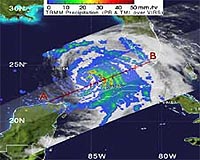
Huntsville AL (SPX) Sep 12, 2008 Hurricane Ike hasn't been strengthening yet as of Thursday morning, Sept. 11, but he is getting larger. Ike is a very large tropical cyclone with hurricane force winds as far out as 115 miles from Ike's center and tropical storm force winds outward to 275 miles! As of 10:00 a.m., Sept. 11, hurricane warnings are up from Morgan City Louisiana to Baffin Bay, Texas. Hurricane conditions could reach the coast within the warning area by late Friday, Sept. 12. At that time, Ike's center was located near 25.5 north and longitude 88.4 west, or 580 miles east-southeast of Corpus Christi, Texas. That's also about 470 miles east-southeast of Galveston, Texas. Ike is a Category 2 hurricane with maximum sustained winds near 100 mph. He is forecast to strengthen to a Category 3 storm before reaching the Texas coastline. Ike is moving west-northwest near 10 mph and will be near the coast late on Sept. 12, however, because Ike is large, tropical storm force winds will be felt far in advance. NASA's TRMM spacecraft observed this view of Hurricane Ike on September 10, 2008 as slammed into Cuba. The storm was a category 1 hurricane with sustained winds of 75 knots (86.25 mph) and a pressure reading of 963 millibars. TRMM's data and aircraft reports confirm the small inner eye is eroding as the outer bands, shown here as red towers, are becoming better defined. This could limit rapid intensity development in the very near term, but the storm is projected to strengthen before it makes landfall. The cloud cover in this animation is taken by TRMM's Visible and Infrared Scanner(VIRS) and the GOES spacecraft. The rain structure is taken by TRMM's Tropical Microwave Imager (TMI) and TRMM's Precitation Radar(PR) instruments. TRMM looks underneath of the storm's clouds to reveal the underlying rain structure. The colored isosurface uner the clouds show the rain seen by the PR instrument. This surface is colored according to cloud height where yellow represents 10 km thunderclouds and red represents 12 km more intense thunderclouds. Related Links More on Ike Earth Observation News - Suppiliers, Technology and Application
 Washington DC (SPX) Sep 12, 2008
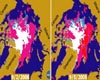
There has been considerable interest in the recent state of Arctic sea ice for scientific research and for operational applications especially along the Northern Sea Route and the Northwest Passage. This pair of sea ice maps was derived from radar data from NASA's QuikScat satellite scatterometer on September 2, 2008 (left panel) and September 5, 2008 (right panel). |
|
| The content herein, unless otherwise known to be public domain, are Copyright Space.TV Corporation. AFP and UPI Wire Stories are copyright Agence France-Presse and United Press International. ESA Portal Reports are copyright European Space Agency. All NASA sourced material is public domain. Additional copyrights may apply in whole or part to other bona fide parties. Advertising does not imply endorsement, agreement or approval of any opinions, statements or information provided by Space.TV Corp on any Web page published or hosted by Space.TV Corp. Privacy Statement |