|
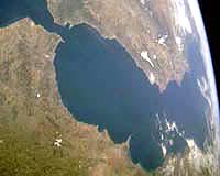
Granada, Spain (SPX) Feb 06, 2008 Africa and Europe get about 4 mm closer every year in a northeast convergence direction. The exact position and geometry of the boundary between the African and Eurasian plates is unknown, but it is located near the Gibraltar Arc - an area of intense seismic activity which was not studied deeply until now. A group of researchers from the Andalusian Institute for Earth Sciences (CSIC) and the Department of Geodynamics of the University of Granada (UGR) described for the first time the physical and mechanical properties of the uppermost part of the Earth's crust - to a depth of 30 km which is where the highest magnitude earthquakes occur. This study has made it possible to establish the exact position of the active faults of the Gibraltar Arc area which cause earthquakes, thus obtaining valuable geological information which could help determine the areas in which earthquakes are most likely to occur. The author of this study is Fermin Fernandez Ibanez, whose doctoral thesis Sismicidad, reologia y estructura termica de la corteza del Arco de Gibraltar (Seismicity, reology and thermal structure of the Gibraltar Arc crust) was directed by researchers Juan Ignacio Soto Hermoso and Jose Molares Soto. This study, which was carried out within the CSIC project entitled The Gibraltar Arc System: Active Geodynamic Processes in the South-Iberian Margins (SAGAS), made the most comprehensive radiography so far in the faults of the Alboran Sea, the westernmost portion of the Mediterranean Sea. The researchers characterised a region of intense deformation in which the relative movement of blocks is caused by left-lateral strike-slip faults known as "the Transalboran fault system," which expands from Murcia (Spain) to Alhucemas (Morocco). The other significant fault of the Gibraltar Arc area, which crosses the Transalboran fault perpendicularly, is called Nerja-Yusuf and goes from Malaga (Spain) to the Algerian coast.
Study of oil wells This doctoral thesis could help to prevent natural disasters like the one that occurred in Indonesia in 2004, when a tsunami killed more than 300,000 people and flooded entire cities. In any case, researcher Fernandez stated that although the Gibraltar Arc is an area of intense seismic activity and the movements of the faults could produce tsunamis, it is almost impossible that such a phenomenon would occur. In addition, the study conducted at UGR related for the first time the temperature of the Earth's crust to its seismic activity, thus determining that the probability of earthquakes is significantly lower in areas of higher temperature. Therefore, the western area of Sierra Nevada and Alhucemas (which are located within the Gibraltar Arc) is the area in which most earthquakes occur due to low temperatures in the Earth's crust, while the area of Almeria (Spain) and the eastern area of the Alboran Sea will probably experience fewer seismic movements. Results from this interesting study were published in renowned scientific journals like the Journal of Geophysical Research or Tectonics. The research group in which researchers Fernandez and Soto participate is a member of Topo-Iberia, an important project which aims at creating an unprecedented temporal seismic broadband net in Spain, composed by a minimum of 80 seismic stations 50-60 km apart and which will have simultaneous and homogenous coverage in different regions. Furthermore, Topo-Ibseria will create the biggest Spanish GPS net ever created. Related Links University of Granada (UGR) Bringing Order To A World Of Disasters When the Earth Quakes A world of storm and tempest
 Tel Aviv, Israel (SPX) Feb 07, 2008
One of the world's most vulnerable areas for earthquakes lies in a region important for Palestinians, Jordanians, and Israelis, around the ancient city of Jericho. A serious earthquake could add to the volatile situation in the Middle East. Hoping to mitigate the risks, Tel Aviv University seismologist Hillel Wust-Bloch from the Department of Geophysics and Planetary Sciences recently masterminded a new earthquake mapping research partnership between Jordanian, Palestinian, and Israeli scientists. |
|
| The content herein, unless otherwise known to be public domain, are Copyright Space.TV Corporation. AFP and UPI Wire Stories are copyright Agence France-Presse and United Press International. ESA Portal Reports are copyright European Space Agency. All NASA sourced material is public domain. Additional copyrights may apply in whole or part to other bona fide parties. Advertising does not imply endorsement, agreement or approval of any opinions, statements or information provided by Space.TV Corp on any Web page published or hosted by Space.TV Corp. Privacy Statement |