|
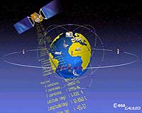
Paris, France (ESA) Aug 10, 2007 The detection of emergency beacons will be greatly improved by the introduction of Europe's satellite positioning system, Galileo. The Galileo satellites will carry transponders to relay distress signals to search and rescue organisations. In connection with this, representatives of the Galileo project attended the recent 21st annual Joint Committee Meeting of COSPAS-SARSAT, the international programme for satellite-aided search and rescue. The partners in Galileo are committed to developing the Galileo search and rescue component as an integral part of MEOSAR, the future worldwide search and rescue satellite system. Galileo joined the meeting in a formal capacity as a major contributor to the MEOSAR programme, following the signature of the 'Declaration of Intent to Cooperate on the Development and Evaluation of MEOSAR'. MEOSAR, which stands for Medium Earth Orbit Search And Rescue, is a programme to equip satellites that operate in medium-Earth orbits with payloads that receive signals from distress beacons on Earth. These signals are then relayed to rescue organisations, giving them the location of the emergency.
Existing systems Search and rescue transponders on geostationary satellites can constantly view a large, fixed area of the Earth, thereby eliminating the time delay in detecting distress signals. However, they are not able to automatically determine the location of the distress beacon as the low-Earth orbit system does. They have to rely on the beacon to use a navigation system to find its position and include it in the distress call. Emergency beacons need to have a direct line-of-sight to the geostationary satellites. There are some situations where this is impossible, such as near the Earth's poles, where the satellites are too low in the sky to be usable, or when an accident happens on the 'wrong' side of a mountain or in a deep valley, and the surrounding terrain obscures the satellite.
Future improvements The Galileo search and rescue component will provide two services. The Forward Link Alert Service, fully backward compatible with the current operational COSPAS-SARSAT components and interoperable with all other planned MEOSAR elements, detects activated distress beacons and notifies the appropriate rescue body. A novel service, known as the Return Link Service, will send a return message to the emergency beacon, notifying the emergency victims that their distress signal has been received and help is on its way. The Galileo In-Orbit Validation Programme, which will have four satellites fitted with search and rescue transponders, will demonstrate the Galileo MEOSAR services. Galileo is a joint initiative between ESA and the European Commission. When fully deployed in the early years of the next decade, it will be the first civilian positioning system to offer global coverage. Related Links Galileo website (European Commission) European GNSS Supervisory Authority (GSA) COSPAS-SARSAT GPS Applications, Technology and Suppliers
 Geneva (AFP) Jul 24, 2007
Swiss council workers had to chop down part of a tree to clear a German truck which got stuck in a narrow dead end because of its driver's blind faith in his onboard navigation system, police said. The 37 year-old driver, who was looking for the factory where he was due to drop off his cargo, ignored several no entry signs to turn into the obviously narrow pedestrian lane in broad daylight, police in the Lucerne region said. |
|
| The content herein, unless otherwise known to be public domain, are Copyright Space.TV Corporation. AFP and UPI Wire Stories are copyright Agence France-Presse and United Press International. ESA Portal Reports are copyright European Space Agency. All NASA sourced material is public domain. Additional copyrights may apply in whole or part to other bona fide parties. Advertising does not imply endorsement, agreement or approval of any opinions, statements or information provided by Space.TV Corp on any Web page published or hosted by Space.TV Corp. Privacy Statement |