 |
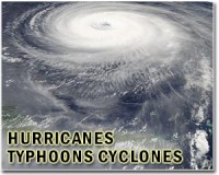
Raleigh, North Carolina (AFP) Sept 1, 2010 Thousands of people evacuated North Carolina's barrier islands on Wednesday as a strengthened Hurricane Earl threatened to pound large areas of the US east coast with heavy winds and rough seas. The strongest Atlantic storm of 2010 was on a path to lash the North Carolina coast and then move north, wreaking havoc on the end-of-summer, US Labor Day holiday weekend that usually draws millions to the beaches. At 0000 GMT, Earl, which earlier regained category four status, had sustained winds of 135 miles (215 kilometers), the National Hurricane Center (NHC) said. The eye of the storm was 565 miles (910 kilometers) south-southeast of Cape Hatteras in the Outer Banks -- a narrow band of North Carolina barrier islands. Also in a sign the hurricane season was heating up, the NHC said the fourth storm in the past 11 days, Tropical Storm Gaston, had formed in the Atlantic on Wednesday. Gaston had winds of 40 miles (65 kilometers) per hour and was centered 1,635 miles (2,635 kilometers) east of the Lesser Antilles. But forecasters warned the storm's track could well put it in the path of earthquake-hit Haiti, a worst case scenario now threatening to become reality for the still-reeling island nation. Thousands of quake survivors remain in flimsy, makeshift, open air camps throughout the capital Port-au-Prince and surrounding areas, and observers warn of a further humanitarian catastrophe if the area is hit by a major storm. US officials meanwhile ordered a mandatory evacuation for thousands of visitors plus the estimated 800 residents on North Carolina's Ocracoke Island, where ferry service is the only means of transportation back to the mainland. "The timing is not good for folks trying to enjoy the last good summer weekend, but safety and protection of personal property comes first," said Cyndy Holda, public affairs officer at Cape Hatteras National Seashore. Just to the north, officials in Dare County issued a mandatory evacuation for visitors to Hatteras Island, the easternmost point in the state. The storm was expected to pass about 50 miles (80 kilometers) to the east of the point early Friday. Earl was churning northwest at 18 miles (30 kilometers) per hour, prompting watches and warnings along a wide area of the coastline as far north as Massachusetts. A hurricane warning, meaning hurricane-force winds are expected, was in effect from the Bogue Inlet in North Carolina to the Virginia border. A hurricane watch, which means dangerous conditions are a possibility, was in effect from the North Carolina-Virginia border to Delaware and all the way to Massachusetts, including the tourist islands of Martha's Vineyard and Nantucket. Tropical storm warnings or watches were in effect around the Chesapeake Bay and parts of the New Jersey coast. National Park officials anticipate a heavy storm surge on Hatteras Island as early as Thursday, when high tide occurs, possibly resulting in road closures. Briefed by top disaster response aides, US President Barack Obama said officials were preparing for the "worst case" scenario and would do all they could to protect vulnerable east coast communities. Airlines said they may cancel flights if conditions worsen. "Storm conditions are expected to make air travel difficult along the east coast, forcing some delays and cancellations of flights at airports in the region, including at its New York hub at Newark Liberty International Airport," Continental Airlines said. Projections showed Earl could remain a powerful storm as it moves toward New England and possibly on to the Canadian coast. "Interests in northern New England and southeastern Canada should monitor the progress of Earl," the hurricane center said.. Earl, which brushed past Puerto Rico on Tuesday, pummeled the Bahamas and eastern Caribbean with rain and heavy winds that downed trees, damaged homes, blocked roads and snapped power lines. Throughout the day on Wednesday, the Bahamas were due for large swells that "could cause dangerous surf conditions and rip currents," the NHC warned. Earl comes on the heels of Hurricane Danielle, blamed for rough surf and riptides in New York and New Jersey last weekend. Meanwhile, tracking closely behind Earl is Tropical Storm Fiona, moving north of Leeward Islands, packing top winds of 60 miles (95 km) per hour, with no immediate threats to land areas.
Share This Article With Planet Earth
Related Links Bringing Order To A World Of Disasters When the Earth Quakes A world of storm and tempest
 US coast braces for 'large and intense' Hurricane Earl
Miami (AFP) Aug 31, 2010 Hurricane Earl churned toward the US mainland Tuesday, posing a threat to a big beach holiday weekend over a vast section of the eastern seaboard after pummeling several Caribbean islands with heavy winds and rain. A hurricane watch was issued for the North Carolina coast, the National Hurricane Center said, calling Earl a "large and intense" storm. Earl remained a strong category four h ... read more |
|
| The content herein, unless otherwise known to be public domain, are Copyright 1995-2010 - SpaceDaily. AFP and UPI Wire Stories are copyright Agence France-Presse and United Press International. ESA Portal Reports are copyright European Space Agency. All NASA sourced material is public domain. Additional copyrights may apply in whole or part to other bona fide parties. Advertising does not imply endorsement,agreement or approval of any opinions, statements or information provided by SpaceDaily on any Web page published or hosted by SpaceDaily. Privacy Statement |


 del.icio.us
 Digg
Digg Reddit
 YahooMyWeb
 Google