 |
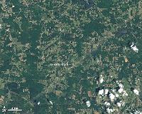
Redlands CA (SPX) May 04, 2011 Working in close collaboration with the US Department of the Interior (DOI), Esri is pleased to announce the release of Landsat image services. These provide access to almost four decades' worth of Global Land Survey (GLS) Landsat data developed by the National Aeronautics and Space Administration (NASA) and DOI's US Geological Survey. Esri provides access to the full multispectral, multitemporal Landsat data for free on ArcGIS Online as dynamic image services. "These Landsat image services expand the ability to monitor landscape change to Internet users worldwide," says Jack Dangermond, president of Esri. "We're excited to showcase this valuable government resource that uses ArcGIS to rapidly deliver Landsat data so that it can be used to help users understand changes in the world." Esri has also published an interactive website that leverages these Landsat image services to provide a starting point for understanding earth changes over time. "The Esri Landsat services suite will enable users to access satellite images of the earth and see through time what's happened to our globe," stated Deputy Secretary of the Interior David J. Hayes. "Whether you're a fourth grader or in the midst of writing your PhD thesis, having the ability to go back 30 years and visualize multitemporal earth imagery can be tremendously helpful in answering questions about how we should manage the planet and address real-world problems." The Landsat image services from Esri leverage the 40-year, multibillion-dollar US government investment in the collection and archiving of continuous worldwide Landsat imagery for earth observation. At 30-meter spatial resolution, Landsat imagery is excellent for mapping regional trends in climate change, agriculture, wildlife habitat, forestry, regional planning, coastal zones, and national security. Each Landsat satellite image also "sees" more than humans by collecting data in nonvisible wavelengths such as the infrared and optical (natural color) portions of the electromagnetic spectrum.
Share This Article With Planet Earth
Related Links More information here Earth Observation News - Suppiliers, Technology and Application
 Satellites Reveal Tornado Tracks in Georgia, Mississippi and Alabama
Greenbelt MD (NASA) May 03, 2011 Tornado tracks from last week's powerful tornado outbreak are visible in data from NASA's Aqua satellite and the Landsat satellite. Among the more than 150 tornadoes reported on April 27 and 28, 2011, was a rare EF-5 storm. Such a storm has the capacity to collapse a concrete building. The tornado hit Smithville, Mississippi, where it killed at least 14 people, and moved northeast nearly 3 ... read more |
|
| The content herein, unless otherwise known to be public domain, are Copyright 1995-2010 - SpaceDaily. AFP and UPI Wire Stories are copyright Agence France-Presse and United Press International. ESA Portal Reports are copyright European Space Agency. All NASA sourced material is public domain. Additional copyrights may apply in whole or part to other bona fide parties. Advertising does not imply endorsement,agreement or approval of any opinions, statements or information provided by SpaceDaily on any Web page published or hosted by SpaceDaily. Privacy Statement |


 del.icio.us
 Digg
Digg Reddit
 YahooMyWeb
 Google