 |
Greenbelt MD (SPX) May 11, 2011 How do instruments end up on satellites orbiting the Earth? For many of them, long before they are ever launched into space, they are tested from NASA airplanes. One of the objectives of the NASA Airborne Science Program is to test new instruments in space-like environments. Testing future satellite instruments from airplanes is the next best thing to actually testing them in space. Over the past three weeks, a team from NASA's Goddard Space Flight Center, Greenbelt, Md., led by Bill Heaps has been testing a new broadband lidar instrument on NASA's DC-8 flying laboratory that they hope will fly on the ASCENDS satellite mission. ASCENDS, an acronym for Active Sensing of Carbon dioxide Emissions over Nights, Days and Seasons, is an upcoming NASA satellite expected to be launched in 2018-2020. The goal of the ASCENDS mission is to measure the sources, distribution and variations in carbon dioxide gas with very high precision all over the Earth. Mapping carbon dioxide is important for understanding the global carbon cycle and for modeling global climate change.
How is carbon dioxide measured from space? Heaps' broadband lidar - an acronym for light detection and ranging - uses an infrared laser beam aimed at the surface of the Earth. As the laser passes through the atmosphere and bounces off the ground, carbon dioxide molecules in the atmosphere absorb some of the light from the laser. Measuring the amount of absorption that occurs as the instrument passes over different locations on the Earth will allow the team to build global carbon dioxide maps. Typical lidar systems have lasers that emit light at very specific colors, or wavelengths. The carbon dioxide molecule, however, absorbs light at a several different infrared wavelengths. The broadband laser used in Heaps' instrument emits light with a broader range of wavelengths, and thus has the advantage of being able to detect carbon dioxide absorption in multiple wavelength bands with one laser. The wavelength control requirements are also less strict than for a more conventional narrowband laser, which may make the system easier to implement on a satellite. The Goddard team worked for over two weeks to install and test their instrument in the belly of the DC-8 at the NASA Dryden Aircraft Operations Facility in Palmdale, Calif. The team then flew with their instrument on two four-hour flights on the converted jetliner during the week of May 2 - 6 over northern and central California. During the flights, they tested the instrument's performance at variety of altitudes and over different types of surfaces - deserts, agricultural fields, mountainous terrain, the ocean and the flat waters of Lake Tahoe. The team was very pleased with the performance of the instrument. "The system definitely measured CO2 on both flights, even transmitting a very small amount of laser power. I believe the broadband technique has excellent potential to be scaled up for measurements from space," Heaps said. This July, several instrument teams, all vying to have their instrument fly on ASCENDS, will test their instruments side-by-side on the DC-8. With data from the test flights of the broadband lidar instrument in hand, Heaps' team will return to Goddard to make refinements and improvements in the hope that their instrument will be chosen to fly on the ASCENDS satellite mission. The NASA Earth Science Technology Office Instrument Incubator program provided funding for the Goddard broadband lidar.
Share This Article With Planet Earth
Related Links Goddard Space Flight Center Space Technology News - Applications and Research
 Northrop Grumman's Astro Aerospace Delivers Deployable Reflector to Astrium for Alphasat I-XL Spacecraft
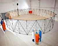
Carpinteria CA (SPX) May 10, 2011 Astro Aerospace has delivered its fourth deployable AstroMesh reflector to Astrium in Toulouse, France, this one for the Alphasat I-XL spacecraft that will provide commercial, broadband telecommunications services to Europe, Middle East, Africa and parts of Asia. The 11-meter reflector is the latest in a line of successful AstroMesh deployable, large aperture reflectors developed and built ... read more |
|
| The content herein, unless otherwise known to be public domain, are Copyright 1995-2010 - SpaceDaily. AFP and UPI Wire Stories are copyright Agence France-Presse and United Press International. ESA Portal Reports are copyright European Space Agency. All NASA sourced material is public domain. Additional copyrights may apply in whole or part to other bona fide parties. Advertising does not imply endorsement,agreement or approval of any opinions, statements or information provided by SpaceDaily on any Web page published or hosted by SpaceDaily. Privacy Statement |


 del.icio.us
 Digg
Digg Reddit
 YahooMyWeb
 Google